Saving traditional orchards
The case of Gloucestershire shows the historical relationship between orchards and large houses, and how orchards can influence planning and development.
|
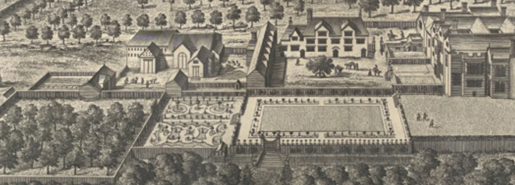
| Great Barrington: the orchard is recognisable from the neat, ordered arrangement of trees. Johannes Kip engraving, reproduced with the kind permission of Gloucestershire Archives. |
Contents |
Introduction
When surveyors were preparing the wonderful series of 25-inch-to-the-mile maps (1:2,500) for the Ordnance Survey in the late 19th century, they were able to indicate orchards, though not whether plum, pear, cherry or apple, using a symbol of a small tree arranged neatly and systematically within a defined area. These maps are the first detailed and widespread evidence for the existence of orchards in any area. The maps support the statement from The Victoria History of the County of Gloucester (VCH) II that, before 1914, ‘on the whole Gloucestershire is an orchard county’.
Modern comparisons between assessments of the acreage shown on those large-scale maps with those existing 100 years later shows a dramatic change: four fifths of the traditional orchards no longer exist and a meagre seven per cent have been replaced with modern orchards, grown to less environmentally valuable standards, if greater economic value. The picture is only a little less dramatic nationally: 18 per cent of traditional orchards survive, but a quarter have been replaced with modern-style orchards. [1] The decline in orchard acreage started between the wars, but since 1950 it has been precipitous.
Historical evidence
Early evidence of orchards is patchy, relating to particular estates or to literary comment. In English Orchards, Barnes and Williamson have collected much literary evidence for the whole country, though they have a paucity of evidence for Gloucestershire. [2] Orchards were not like fields of wheat or barley, which might cover many acres, but were small enclosures most commonly associated with pasture or grass land. The name ‘orchard’ itself shows that each area of fruit trees was relatively small; it derives from a combination of Latin hortus, ‘garden’, and ‘yard’. ‘Orchard’ has not been a source of placenames, unlike the word ‘apple’, which was identifying places before 1066; the few names which appear to refer to orchards have a different origin. Stoke Orchard in Gloucestershire derives from the manorial family of Archer, changed by popular etymology, though perhaps an indication of the presence of orchards in the area.
An orchard was often among the immediate surroundings of large houses. The engravings by Johannes Kip, published in 1712 in The Ancient and Present State of Glostershire, Sir Robert Atkyns life’s work, illustrate how often the Gloucestershire gentry’s houses had an orchard nearby. As on the Ordnance Survey maps, they are recognisable from the neat, ordered arrangement of trees, some arranged in a quincunx pattern (in fives), as seems to be the case in the orchard at Great Barrington. Some were clearly decorative features; this seems to be the case with the orchard in the iron-age hill fort at Knole, where Thomas Chester Esq had built a new manor house in the later 16th century, moving from the village site in Almondsbury.
While an orchard might have supplied a small cash sum for the farmer, it was mainly a source of fruit for the household and for the production of cider for the house and for farm workers. The writer of the earliest volume of The Victoria History of the County of Gloucester, published in 1907, commented that ‘a good deal of fruit is grown by small holders and owners’, noting particularly that apples and plums ‘are grown in large quantities for cider and perry, and orchard planting is on the increase’. The writer also noted that ‘speaking generally, orchards have not been as well-managed as might have been the case, and have not been regularly replenished with young trees to take the place of those that have become unserviceable’.
Measuring traditional orchards
Modern concern about the disappearance of traditional orchards, which are valuable wells of biodiversity, stimulated their designation in 2007 as protected habitats. Natural England and the National Trust led a research project with the People’s Trust for Endangered Species to compile an inventory of surviving examples. They used modern technological tools: scans of the 25-inch OS maps drawn between 1892 and 1914, AI to identify orchards marked on them and aerial photography to find surviving traditional orchards. Natural England’s report on the Traditional Orchard Project in England was published in 2011 and the results mapped; only 1,521 ha (3,759 acres) of traditional orchards were identified in Gloucestershire.
The National Trust reworked an analysis of the 25-inch maps with a wider remit, comparing the results with the Habitat Action Plan map, and published an interim report, Blossom over Time, in 2022 [3]. It estimated Gloucestershire orchards before the first world war at 8,382 ha, an estimate not very different from Dudley Stamp’s; he had calculated that the acreage of orchard had increased from 4,702 ha in 1875 to over 8,094 ha by 1905. [4] Planting an orchard was one response to the falling prices of agricultural production in the later 19th century. After 1918 the area of orchards started to decline: the Ministry of Agriculture returns for the county in 1939 gave 5,901ha, and after 1950 the fall gathered pace. The National Trust estimate was that only 1,702 ha survived in Gloucestershire.
Cheltenham was one of 10 major towns and cities identified in Blossom over Time where the loss of traditional orchards was most severe. London headed the list, followed by Maidstone and then Cheltenham: 294.33 ha of orcharding before 1914 had fallen to just 3.31 ha. Gloucester is also on this list, with 183.14 ha reduced to 3.43 ha.
Sandfields and Rowanfield
In 1944 Gordon Payne, Gloucestershire County Council planning officer, compiled a comprehensive survey of the county (Gloucestershire: a survey) with post-war planning requirements obviously in mind. Among the county’s resources he recorded areas of market gardening and of good horticultural land. He divided the county into 17 areas; in only four areas were orchards significant, one of which was the Cheltenham market gardening area where ‘apples and plums are important’. In Uckington, 5.4 per cent of the land was orcharding; to the north-west of Cheltenham it was nine per cent; Swindon village had 6.2%, but there was a much smaller area in Prestbury. Payne regretted ‘that considerable tracts of this highest quality horticultural land has been absorbed by building development’. What would he say in 2024?
Payne knew that orchards were being lost between the two world wars, not only because of economic conditions, but because they provided relatively flat and easily prepared sites for housebuilding. Cheltenham Borough Council was under pressure to clear some of the town centre properties designated as slums; orchards to the north of the Gloucester Road were sacrificed from 1919 for the council’s first housing estate, now known as the Poets’ Estate. Bomb damage during the second world war added to the housing problem and after the war population increase gathered momentum. In 1921 Cheltenham’s population was 48,430; in 2021 it was 118,800.
Sandfields and Rowanfield are graphic examples. These fields were to the north-west of the town centre and were extensively planted with orchard. Sandfields was filled with houses just before 1939 and Rowanfield shortly after in 1945.
Until 1835, the fields had been mainly open arable land shared between the farmers of Alstone and Arle tithings or townships in Cheltenham manor. Sandfields’ name reflected the easily worked nature of the soil. Rowanfield was not distinguished by rowan trees but like Stoke Orchard has a misleading name. The field was where the farmers of Alstone were entitled to graze their animals after the crop had been taken: ‘rowan’ is a corruption of rewain, the old Norman French word for ‘aftermath’. [5] When enclosed in 1835, the land allocated to each owner made use of boundaries of former arable strips.
Each owner’s land was colour-washed on the 25-inch maps illustrated; these maps were specially prepared in 1911 for the Lloyd George survey of land values. In his People’s Budget of 1909, the chancellor of the exchequer, David Lloyd George, had pledged to tax landowners on the increase in the value of the land whenever it thereafter changed hands. The 25-inch maps also show numerous orchards in the western half of the county, but here the pressure of housing needs has not been so great and more have survived.
There were several owners in Sandfields and several tenants, and some orchards were attached to larger houses built after 1835. Orchard Avenue, Orchard Way, Bramley Road, Laxton Road and Russet Road, an estate of semi-detached houses, was built in 1938-9. Cheltenham Borough Council apparently felt conscious of the destruction of the orchards. When Orchard Drive and Orchard Gardens were suggested, the builders, Pye Bros, were asked to think of different names. Hawthorn Road and Tanners Road were approved instead. [6]
In 1946, the council approved the layout of the estate at Rowanfield, though building did not start until 1949. By the summer of 1950, George Wimpey and Co had built 394 houses, again mainly semi-detached. The estate had a spacious layout, and a substantial area of Rowanfield was preserved as open space. The Avenues were all named after southern counties: Bedford, Buckingham, Cambridge, Devon, Dorset, Cornwall, Norfolk, Somerset, Surrey and Sussex.
Other housing estates were being built on farmland around Cheltenham, though not all were so full of orchards as the two examples described. The town’s expansion is constricted to south and east by the steep scarp slope of the Cotswold hills, making the sacrifice of good horticultural land to the north and west almost inevitable.
Only in the 21st century has the importance of traditional orchards for biodiversity been recognised. It may be hoped that the preservation of those orchards which have survived, together with the creation of new orchards and community orchards, will influence attitudes to planning. Rather than adding ever more concentric rings of suburban housing round a town, should a different and more imaginative policy be developed and the value of horticultural land generally be given greater recognition?
Acknowledgments
Johannes Kip’s engravings are reproduced with the kind permission of Gloucestershire Archives. The Ordnance Survey maps are reproduced with the kind permission of Gloucestershire Archives and of the Ordnance Survey.
References
- [1] Natural England, Traditional Orchard Project in England, NECR077
- [2] Gerry Barnes and Tom Williamson (2022) English Orchards, Windgather Press/Oxbow Books
- [3] Tom Dommett (2022) Blossom Over Time (National Trust Interim Report)
- [4] Gerry Barnes and Tom Williamson (2022) English Orchards, quoting L Dudley Stamp (1948) The Land of Britain
- [5] AH Smith (1964) The Place-Names of Gloucestershire
- [6] J Hodsdon (1997) An Historical Gazetteer of Cheltenham, Bristol and Gloucestershire Archaeological Society
This article originally appeared in the Institute of Historic Building Conservation’s (IHBC’s) Context 180, published in June 2024. It was written by Anthea Jones, who was head of history and director of studies at Cheltenham Ladies’ College. Now retired, she is the author of several books on Gloucestershire history, including Johannes Kip: the Gloucestershire engravings.
--Institute of Historic Building Conservation
Related articles on Designing Buildings Conservation.
IHBC NewsBlog
200th Anniversary Celebration of the Modern Railway Planned
The Stockton & Darlington Railway opened on September 27, 1825.
Competence Framework Launched for Sustainability in the Built Environment
The Construction Industry Council (CIC) and the Edge have jointly published the framework.
Historic England Launches Wellbeing Strategy for Heritage
Whether through visiting, volunteering, learning or creative practice, engaging with heritage can strengthen confidence, resilience, hope and social connections.
National Trust for Canada’s Review of 2024
Great Saves & Worst Losses Highlighted
IHBC's SelfStarter Website Undergoes Refresh
New updates and resources for emerging conservation professionals.
‘Behind the Scenes’ podcast on St. Pauls Cathedral Published
Experience the inside track on one of the world’s best known places of worship and visitor attractions.
National Audit Office (NAO) says Government building maintenance backlog is at least £49 billion
The public spending watchdog will need to consider the best way to manage its assets to bring property condition to a satisfactory level.
IHBC Publishes C182 focused on Heating and Ventilation
The latest issue of Context explores sustainable heating for listed buildings and more.
Notre-Dame Cathedral of Paris reopening: 7-8 December
The reopening is in time for Christmas 2025.
Stirling Prize-winning Salford building to be demolished
The Centenary Building will be bulldozed as part of the wider £2.5bn Crescent regeneration project.


